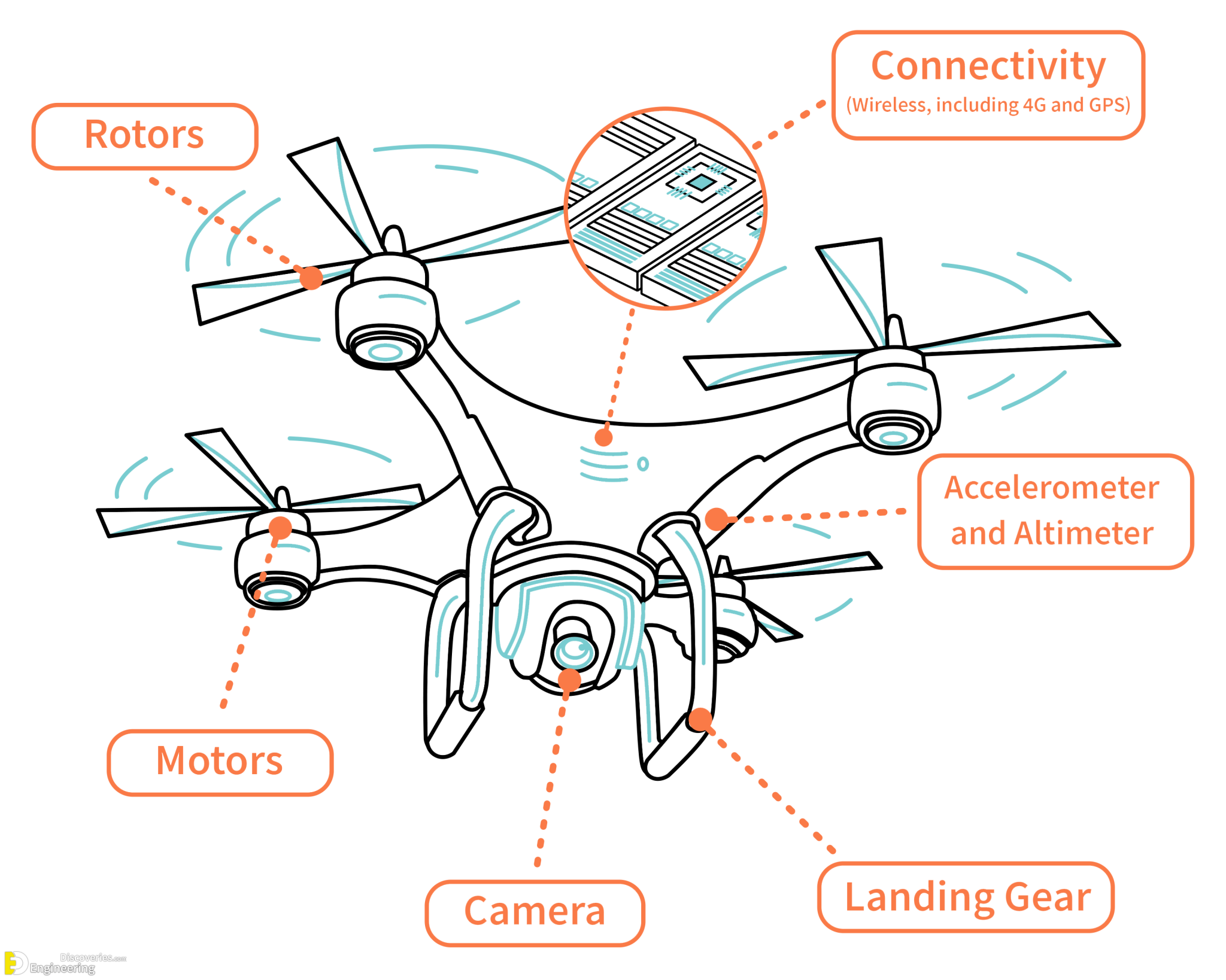
How to use drone – How to use a drone? It’s a question many ask, and the answer is surprisingly multifaceted. From selecting the perfect drone for your needs to mastering complex flight maneuvers and understanding crucial safety regulations, the journey into the world of drone operation is filled with exciting challenges and rewarding experiences. This guide provides a structured approach, leading you through each step, from beginner to more advanced techniques, ensuring a safe and enjoyable experience.
We’ll cover everything from choosing the right drone based on your budget and intended use, to understanding and adhering to relevant safety regulations and legal requirements. We’ll then delve into mastering flight controls, utilizing drone camera features for stunning aerial shots, and performing essential maintenance tasks to extend the life of your drone. Finally, we’ll explore advanced techniques and various industry applications, showcasing the incredible versatility of this technology.
Mastering Drone Flight Controls

Understanding and mastering drone flight controls is crucial for safe and effective operation. This section will cover the fundamentals of drone piloting, from basic maneuvers to compass and GPS calibration. Safe and responsible drone operation requires a thorough understanding of these principles.
Basic Drone Flight Controls
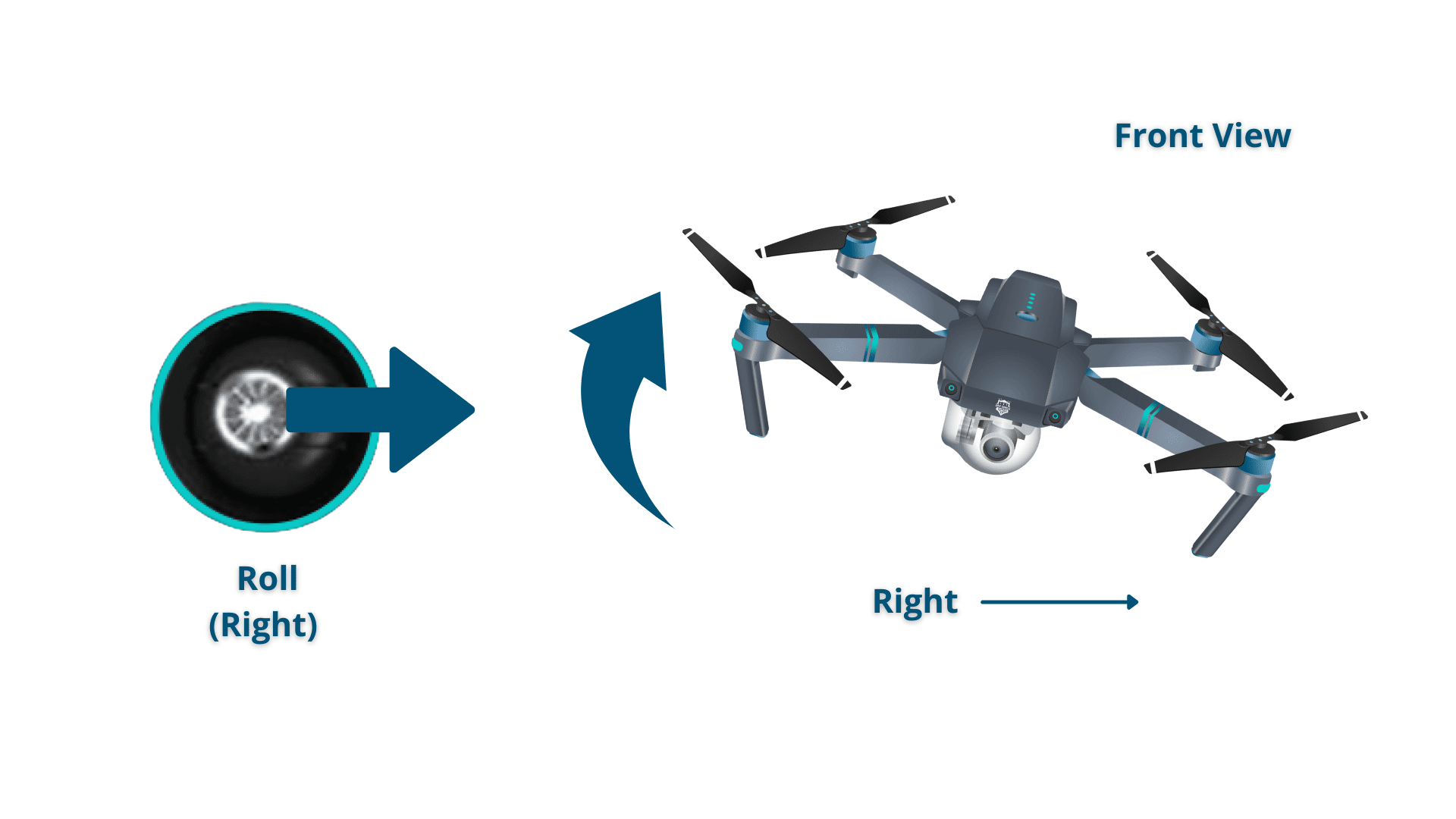
Drone flight controls typically involve joysticks or a touchscreen interface controlling throttle (altitude), yaw (rotation), pitch (forward/backward movement), and roll (left/right movement). Takeoff usually involves engaging a motor-start sequence and gradually increasing throttle until the drone lifts off. Landing is the reverse process, slowly lowering the throttle until the drone gently touches down. Directional movement is achieved by using the roll and pitch controls to tilt the drone in the desired direction.
Altitude adjustments are made using the throttle control, increasing it to ascend and decreasing it to descend.
Compass and GPS Calibration
Accurate flight relies heavily on proper calibration of the drone’s compass and GPS. Compass calibration involves a process of slowly rotating the drone in a complete circle, typically several times, allowing the internal compass to orient itself to the Earth’s magnetic field. This ensures accurate heading information. GPS calibration requires the drone to be stationary in an open area with a clear view of the sky, allowing it to acquire sufficient satellite signals for precise positioning.
This process often involves waiting for a specified number of satellites to be acquired before flight is permitted. Incorrect calibration can lead to erratic flight behavior and inaccurate positioning data.
Performing Flight Maneuvers
Hovering involves maintaining a stable position in the air, requiring precise control of the throttle and other axes to counteract wind and other external forces. Circling is achieved by using a combination of yaw and roll or pitch controls to create a circular flight path. Smooth transitions between altitudes and speeds are accomplished by gradually adjusting the throttle and pitch/roll controls, avoiding sudden movements that can destabilize the drone.
Practicing these maneuvers in a safe, open area is essential to develop proficiency and confidence. For instance, starting with slow, controlled movements and gradually increasing speed and complexity as skills improve is a recommended approach. Smooth transitions are crucial for creating high-quality aerial footage and avoiding abrupt movements that could damage the drone or compromise safety.
Advanced Drone Techniques

Mastering basic drone flight is just the beginning. To truly unlock the potential of your drone, understanding and utilizing advanced techniques is crucial. These techniques allow for more complex and creative aerial photography and videography, as well as more efficient and precise data collection for various applications. This section will explore waypoint navigation, autonomous flight modes, and effective camera angle utilization.
Waypoint Navigation and Autonomous Flight Modes
Waypoint navigation allows you to pre-program a flight path for your drone, specifying a series of points (waypoints) it will follow autonomously. This eliminates the need for constant manual control, enabling complex shots and freeing up the pilot to focus on camera operation. Autonomous flight modes, often integrated with waypoint navigation, offer features like orbit mode (circling a subject), follow mode (tracking a moving subject), and return-to-home (RTH), ensuring safe and efficient operation.
These features are typically accessed and configured through the drone’s accompanying software application. Careful planning and understanding of your drone’s capabilities are essential to ensure successful autonomous flights. For instance, selecting appropriate altitudes and speeds for each waypoint, considering wind conditions and potential obstacles, are critical aspects of effective waypoint mission planning.
Drone Software for Flight Planning and Mission Control
Most drones come with dedicated software applications for iOS and Android devices or desktop computers. These applications provide a user-friendly interface for planning and executing complex flights. They typically allow users to create waypoints on a map, set altitude and speed parameters for each segment of the flight, adjust camera settings remotely, and review flight logs. Some advanced software packages offer features like obstacle avoidance, geofencing (restricting the drone’s flight area), and automated data processing for applications like surveying or inspection.
For example, DJI Fly and Litchi are popular applications offering a range of features from basic waypoint navigation to advanced mission planning and autonomous flight capabilities. Understanding the specific functionalities of your drone’s software is vital for maximizing its potential.
Camera Angles and Their Effects
Different camera angles dramatically alter the mood, perspective, and overall impact of your aerial footage.
Operating a drone safely and effectively requires understanding its controls and capabilities. Learning the basics, from pre-flight checks to maneuvering, is crucial for a positive experience. For a comprehensive guide covering all aspects, from takeoff to landing, check out this excellent resource on how to use drone and master the art of aerial photography or videography.
Remember always to prioritize safety and follow all relevant regulations when operating your drone.
High Angle Shot (Bird’s-eye view): Imagine looking straight down from a significant height. This angle provides a broad overview, showcasing the scale and context of the scene. Think of a wide shot of a cityscape or a vast landscape. It often emphasizes size and spatial relationships.
Low Angle Shot: Picture the camera positioned close to the ground, looking upwards. This angle can make the subject appear larger, more powerful, or even intimidating. A low-angle shot of a building, for example, can emphasize its height and grandeur.
Operating a drone safely and effectively requires understanding its controls and capabilities. For beginners, mastering basic flight maneuvers is crucial before attempting more complex operations. A comprehensive guide on how to use drone can provide valuable insights into various aspects, including flight planning and emergency procedures. Ultimately, responsible drone operation hinges on consistent practice and adherence to safety regulations.
Dutch Angle (Canted Angle): This involves tilting the camera to one side, creating a sense of unease, disorientation, or chaos. It’s often used in dramatic scenes to convey tension or instability. Imagine a slightly tilted shot of a storm-ravaged landscape.
Eye-Level Shot: This shot is taken at the subject’s eye level, offering a neutral and relatable perspective. It can create a sense of intimacy and connection with the subject. Consider an eye-level shot of a person walking through a forest.
Oblique Angle: This is a shot taken from a diagonal perspective, offering a dynamic and visually interesting viewpoint. It can create a sense of movement and energy. Think of a diagonal shot of a winding river.
Drone Applications in Various Industries: How To Use Drone

Drones, or unmanned aerial vehicles (UAVs), have rapidly transitioned from a niche hobbyist pursuit to a powerful tool across diverse industries. Their versatility, coupled with advancements in technology and decreasing costs, has unlocked unprecedented opportunities for efficiency, safety, and data acquisition in ways previously unimaginable. This section explores the varied applications of drones, comparing their benefits and limitations across key sectors.
The use of drones varies significantly depending on the specific industry needs. While some industries benefit from drones’ ability to access difficult-to-reach areas, others leverage their data-gathering capabilities for improved decision-making. Understanding these nuances is crucial for effective drone implementation.
Drone Applications in Agriculture, How to use drone
Precision agriculture is revolutionized by drones. Equipped with multispectral or hyperspectral cameras, drones capture high-resolution imagery providing detailed information about crop health, identifying areas of stress, nutrient deficiencies, or pest infestations. This allows farmers to target their resources efficiently, optimizing fertilizer and pesticide application, ultimately increasing yields and reducing costs. For instance, a vineyard in Napa Valley, California, used drone imagery to identify water stress in specific grapevines, leading to targeted irrigation and a 15% increase in grape yield.
Limitations include the dependence on favorable weather conditions for optimal data acquisition and the need for skilled personnel to interpret the collected data.
Drone Applications in Construction
In the construction industry, drones offer significant advantages in site surveying, progress monitoring, and safety inspections. They can quickly and efficiently generate 3D models of construction sites, allowing for better project planning and management. Regular drone flights provide visual progress reports, identifying potential delays or problems early on. Moreover, drones can inspect hard-to-reach areas, such as bridges or tall buildings, minimizing risks to human inspectors.
A large-scale infrastructure project in Dubai utilized drones to monitor the progress of a massive bridge construction, leading to a 10% reduction in project completion time by identifying and addressing potential bottlenecks early. However, challenges include regulatory hurdles regarding flight permissions in congested urban areas and the need for robust data processing capabilities to handle the large datasets generated.
Drone Applications in Real Estate
Real estate companies utilize drones for creating stunning aerial photography and videography, showcasing properties from unique perspectives and attracting potential buyers. High-resolution images and 3D models provide detailed views of properties and surrounding areas, offering a comprehensive overview that traditional photography struggles to capture. Drones also expedite the property assessment process, allowing for quicker turnaround times. For example, a real estate agency in Miami used drone footage to market luxury waterfront properties, resulting in a 20% increase in sales compared to the previous year.
Limitations include weather dependence for quality aerial shots and the need for post-processing to enhance the visual appeal of the captured media.
Mastering the art of drone operation opens up a world of possibilities, whether you’re a hobbyist capturing breathtaking landscapes or a professional utilizing drones for innovative applications. By carefully following the steps Artikeld in this guide, understanding safety regulations, and continuously honing your skills, you can confidently navigate the skies and harness the power of this remarkable technology. Remember that consistent practice and a commitment to safety are key to becoming a proficient drone pilot.
Embrace the learning process, and enjoy the journey of discovering the endless potential of drones.
FAQ Compilation
What is the best drone for beginners?
Many user-friendly drones with excellent features are available for beginners. Look for drones with features like GPS stabilization, obstacle avoidance, and intuitive controls.
How often should I charge my drone battery?
It’s best to charge your drone battery after each use and avoid fully depleting it. Consult your drone’s manual for specific charging recommendations.
What should I do if I lose signal with my drone?
Most drones have a return-to-home (RTH) function. Activate this immediately if you lose signal. If the RTH fails, try to visually locate your drone and attempt to regain signal.
Can I fly my drone in any location?
No, drone flight is heavily regulated. Always check local and national airspace restrictions before flying. Unauthorized flights can lead to penalties.